
I don’t think I woke up until almost Noon! MMMMM that sure did feel good after not getting much sleep in Pendleton & traveling pretty hard those last two days. Waking up by that little stream was such a treat.

It was hard to leave that place, but alas, the road calls…..
On the way out of town we took a dip in the Wallowa Lake (really nice & clear & cool) while Stella had her daily meltdown. By the time we got into Joseph, she was crashed & we hit a little Mexican joint for dinner. Bellies full, we stocked up on camping supplies & ice & a few little things & gas & headed out to Hat Point, overlooking the Snake River & the Hells Canyon area.
Beautiful country we live in. It is such a pleasure to be able to get out & appreciate it. All in our own state too!
We wound our way through the canyons & sculpted hills along Little Sheep Creek until we came upon Imnaha. The bustling metropolis of Imnaha boasts a closed down meeting hall, the tiniest post office I have ever seen & a general store. Probably hasn’t changed much since it was first settled in the early 1800’s. This is the kind of place where you can almost feel the history, both of the original Native American residents & the white settlers that came later to change this country forever.
The road to Hat Point is 28 miles of really respectable graded dirt & loose rock. Not too many potholes or washboards to speak of. Our neighbor was up here a few weeks back & made it sound like a super scary death defying journey. We were a little concerned when we passed the sign “extreme grades narrow road with no pullouts”, but it really wasn’t that bad.


Nothing compared to the road to Punta Abreojos in Baja, nothing compared to the road to Pena Bruja in Costa Rica, and certainly nothing compared to the road we climbed/crawled up at Elephant Hill in the Canyonlands. When you’ve driven to Costa Rica & back, its hard to find roads that bad in the states.

We hit it just as the sunset golden hour was glowing in the western sky & the babe was sleeping soundly, lulled further into her baby dreams by the smooth shudder of the car over the gravel.


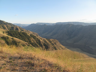
The road traverses the length of the Grizzly Ridge to the South & then juts back to the north east along the edge of a series of ridge plateaus. The geology & sheer force of nature is evident everywhere you look. You are on top of a plateau that has been transformed by the millennia into the steepest canyon grade in North America, dropping an astonishing 8000 feet to the Snake river below. Definitely not as vast as the Grand Canyon or the Canyonlands, but deeper & just as fine an evening can be spent gazing at the wonder of it all.

The lookout at Hat Point was established as a point to spot lightning strikes & fires in the early 1800’s. Back then, one guy lived way the heck out there & would keep an eye out for fires. When he spotted one, he would walk/run or ride his horse to the fire & put it out HIMSELF! Think of how much money our government could save if they stuck to this method of fire/forest management. Crazy settlers, they had some serious cajones in those days.…I think we are getting lazier as a culture as technology becomes more & more capable.


The lookout tower is still there & the view from above is fantastic.


Down below the tower the view is great as well.

Camping nearby is not too shabby either.
No comments:
Post a Comment